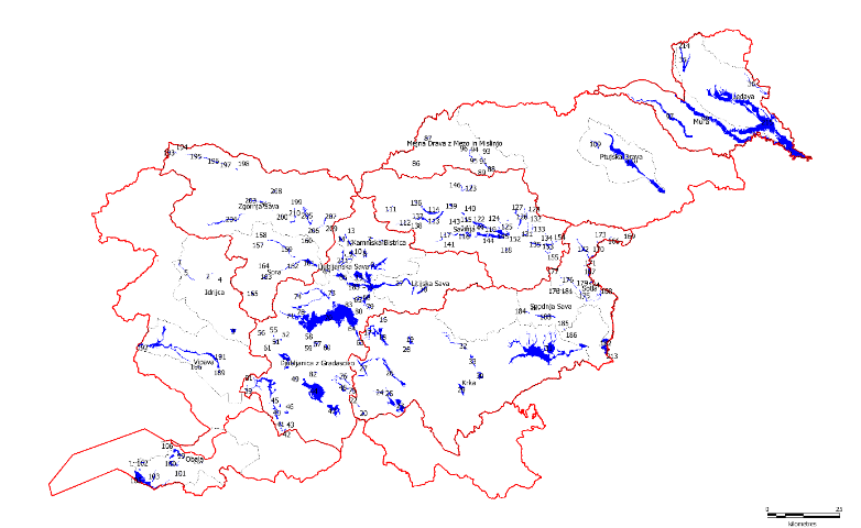
Preliminary Identification of Key Inundation Areas of High Waters in the Area of Slovenia
Significant flood risk areas are defined as part of flooding areas where floodwater can spill and be retained without significant damage, potentially reducing any damaging effects downstream. The Flood Directive prescribes taking into account the areas where floodwater could be retained (natural floodplains). The designation of areas is based on both relevant implementing regulations, i.e. the Decree on Drawing Up a Water Management Plan and the Rules on Mapping Methodology. The importance of the areas is also emphasised in European documents relating to the natural water retention measures, green infrastructure and the achievement of synergies between measures of the Flood Directive and the Water Framework Directive. The main purpose of preparing the expert basis is to preserve and increase the space dedicated to natural flood processes through administrative protection of natural floodplains in the 2015–2021 flood risk management plans.
The chosen method of work is based on a concept that was applied previously in determining the areas of significant impact of floods – a multi-criteria evaluation as support for decision-making by creating 17 raster spatial models of suitability featuring 10m square mesh cells. Six factors that either increase or decrease the level of suitability were considered and for each factor appropriate indicators of the level of suitability and their normalised values were chosen. In addition to the factors, four spatial restrictions were chosen and the suitability of each mesh cell was calculated according to the equation that links suitability with the factors, the factor weights and the restrictions. The result is a classification of the flood areas into five classes of suitability and based on that a classification of flood areas into three classes of suitability according to the boundaries between detailed land use allocations, also taking into account the data on detailed land use of municipal areas divided into three categories. The designed data layers are suitable for use at a scale of 1:50,000.
Based on the results of the suitability model, data from the flood warning map and the integrated map of flood threats, the cadastre of buildings, detailed land use of municipal areas and digital orthophotos, we manually delineated 218 significant flood risk areas in Slovenia and calculated their characteristics. The expert basis is the Flood Directive’s contribution towards achieving the water policy objectives and of the other sectoral policies (nature – biodiversity, agriculture, forestry, spatial development, adaptation to climate change, green infrastructure, etc.), considering that natural water retention positively affects water status by reducing the impact of diffuse sources of pollution, improving the hydromorphological conditions, reducing the impact of frequent flooding and increasing water availability.
Link to Additional Content
Preliminary Identification of Key Inundation Areas of High Waters in the Area of Slovenia. Annual Report on Work on Task I/2/8, Task Leader: Mojca Stele Jeglič. Institute for Water of the Republic of Slovenia, June 2015. Client: Ministry of the Environment and Spatial Planning, Programme of Tasks of IWRS for 2015.
Related Content
Đurović, B. 2012. Determination and Classification of Flood Risk Areas in Slovenia, Summary of the Work Method and the Results, IWRS, Ljubljana. Available at: http://www.mko.gov.si/fileadmin/mko.gov.si/pageuploads/podrocja/voda/metodologija_dolocanja_obmocij.pdf
Classification of Flood Risk Areas and Determination of Areas of Significant Impact of Floods in Slovenia. Annual Report on Work on Task I/2/1.1, Task Leader: Blažo Đurović. Institute for Water of the Republic of Slovenia, May 2012. Client: Ministry of the Environment and Spatial Planning, Programme of Tasks of IWRS for 2012; Available at: http://evode.arso.gov.si/direktive/FD_tabela.htm
Update of the Integrated Map of Flood Threats and the Integrated Map of Classes of Flood Risks for Publication in the Environmental Atlas (60 New HH Studies) and Design of the Integrated Map of Water Depths at Q100. Annual Report on Work on Task I/2/6, Task Leader: Mladen Ajdič. Institute for Water of the Republic of Slovenia, December 2014. Client: Ministry of the Environment and Spatial Planning, Programme of Tasks of IWRS for 2014 (the task has been underway since 2012); Available at: http://evode.arso.gov.si/direktive/FD_tabela.htm
Update of the Flood Warning Map. Annual Report on Work on Task I/2/7, Task Leader: Darko Anzeljc. Institute for Water of the Republic of Slovenia, December 2014. Client: Ministry of the Environment and Spatial Planning, Programme of Tasks of IWRS for 2014.

